Velo Club Moulin

Monday 8 August 2016

Old man strength ~ Wilderness 101, 2016

Before this years Wilderness 101 - a  ~101 mile back country mountain bike race which highlights some of central Pennsylvania's best singletrack - I stocked up on spare tubes and energy goop in Freeze Thaw cycles. With old friend Harry, Justin and the guys who work there we shared a laugh about my lack of preparedness and the fact that, at the end of the day, 'old man strength' would get me through.

I think 'old man strength' is another way of saying pertinaciousness. In other words, the lack of fitness, small number of miles in the legs and poor acclimatisation to the heat and humidity could be overcome by resolve and experience.

I was to put this theory to a harsh test.


It had been many years since my first flirtation with the rocky and demanding trails in Bald Eagle and Rothrock State Forests which form the core of the W101. Years that have not treaded lightly. At the time, I never rode anything other than a singlespeed. I rode tall gears on improbable grades and trails as often as I could. Fitness was not the result of training, just a by product of riding far and often.

Nevertheless, at the time I had never ridden 100 miles off road in one go. I was also nervous of how my rigid bike (with new fangled 29er wheels consisting of crap tyres and Open Pro Mavic road rims and tyre-roll preventing über high pressure) would treat me.

It was tough, but I finished in a respectable time.

In 2016, I had decided to ride a geared, but still rigid bike (albeit with a 29+ front wheel) and although my preparation was relatively poor, I retained confidence in my ability to finish having done several 100 mile races in the USA and UK in the intervening years. This was the experience bit.


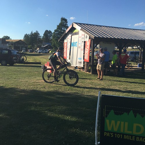
The weather in Pennsylvania was hot and humid (95°f and 90% plus humidity). I had ridden early in the a.m with my friends Frank and Sean, but we were generally done by 10.30 a.m, missing the heat of the day. Come race day, I knew that I needed to get as many miles under my belt as possible early on, otherwise I would suffer. I had all I needed to stay hydrated - 2 bottles and a 1 litre bladder (minimising weight on my back) and my bike was sorted. I had minimal stuff stashed in the 2 drop bags allowed for aid station 2 (which then went to aid 4) and aid 3.

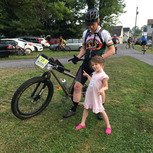
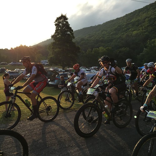
A 5 a.m wake up was less harsh than it could have been due to jet lag and we headed to Coburn park with little time to spare before the start at 7 a.m. Daisy, Trina and good friend Buck waved me off and I tried to just remain calm and in the moment as we pedaled through Coburn and then onto the first forest road of the day.

[The following is my memory of trail name and events and I admit it may have some inaccuracies. The course had changed since I first completed the race and due to it being one big loop, you ride a *lot* of different trails. If there are any glaring errors and you happen to spot them - please let me know!]


The first ~20 miles are on rolling forest road. No difficulties or hard gradients. The weather was warm but as it was so early the humidity hadn't built yet and despite having to stop twice for a loosening bottle cage, I kept the pace up but well within my abilities. Aid 1 was a simple bottle fill and after this I made sure I started to eat some food.

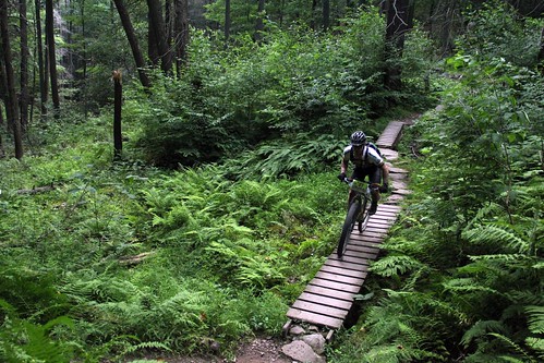
Longberger, Spruce Gap and the Three Bridges Trail brought back memories and I enjoyed the technical riding. A photographer - Derek Bissett - snapped a picture of me still looking pretty lively as I cleared Three Bridges.

Then it was time to climb Laurel Run road and turn onto the Little Shingletown double track descent. Fast as.

The last couple of miles into Aid 2 were on firm road - I cannot remember if it was forest road or even sealed road: I was just glad to have completed the first ~40 miles in 3 hours.

I knew from reading others' reports that there was a monster of a climb out of Aid 2. Seeger road delivered on this threat, no doubt! Up and up it went. the heat and humidity were stifling and the harsh gradient sapped energy from my legs. Keep calm, spin, eat and take in fluids.

At the top of the climb, we turned onto Croyle Run Trail - the first of the really rocky descents. It was clear that I was handling my bike like a sack of potatoes. I struggled to focus on one thing - my eyes were darting to and fro and I was breathing fast and shallow. Noticing my arms were completely dry - no sweat whatsoever - I stopped riding and pulled to the side of the trail in some slight shade and sat for a minute on a rock.

Sometimes my day job can be pretty useful for bike riding and my diagnosis? early heat stroke. I knew I was well hydrated, with electrolyte and I knew I had been riding (just!) within myself. In that sort of humidity, being bone dry while exercising is a clear sign my body's thermometer wasn't registering correctly. Much more of that and things would go south, quickly.

I was just over 50 miles in and the bulk of the hard riding was still to come.

I mulled over the options and in truth there were precious few: call it and give in or find a way to keep moving round the course. The latter was clearly more attractive and a streak of obstinacy (old man strength, remember) acted as an emotional and mental anchor.

Beidlehmeimer, then Bear Meadows roads, before more climbing on Stone Creek and Seeger road led into Aid 3 and a welcome refreshment of fluids. I was still able to take in calories at this point, but most climbs and some of the narrow gauge trails that required a lot of effort meant I had to stop for up to 5 minutes at a time and allow my breathing to slow and the heat to dissipate a bit. It was disappointing as  basically this was not a race for me any more - it was akin to survival.

Climbing Pigpile and then Sasspig and Sassafras trail were next and we were soon in Coopers Gap. I climbed Beautiful trail (it was) and then No Name trail before Lingle Road and Aid 4.

By this stage I could not tolerate electrolyte or food - a worrying sign. My energy levels were dreadful - any effort was draining me. I could feel hot, hot air in my mouth with every breath: I just wanted to cool down.

After Aid 4 I walked up Sand Mountain road as the gradient required too much physical output even in a 32x42 gear and it was only when we continued onto Lingle Valley and Siglerville Pike that I could start pedaling again.

My original aim had been finishing in 9 hours and some. At this rate I would be lucky to come in under 12 hours.

All around me there were racers suffering in the heat. One racer noted the temp on his gps as 100°f (40°c) and I can well believe that.

With a race this long, there are always going to be multiple stings in the tail and although the next trail, Panther Run, wasn't the last it was the most painful. A slight downwards gradient but an absolute mess of sharp mobile and immobile rock. I can't quite describe the intensity of this trail. It got to the stage that I could not control my bike in any meaningful way - fast or slow. I simply let off the brakes and pedaled up to speed and sucked up the impacts, relying on my bike to not break under the onslaught. This went on and on. I stopped and rubbed feeling back into my hands then went again. And again.

I was bellowing without meaning as we finally dropped on to Poe Valley road.


Aid 5 signified 12-13 miles still to go. The old Mingle road climb with it's multiple false summits took  an emotional toll and the Fisherman's trail by the river was barely walkable let alone rideable in my state.

The railroad grade back to Coburn saw me sitting, somewhat petulantly, with my back to my bike, muttering to myself 'I can't do this anymore. I can't do this anymore'. Of course, I knew that I could, I just needed one last chance to slow down, calm my mind and breathing and cool myself as much as possible in the shade. I got going after a brief fit of dry retching.

Why I didn't jump in the river is anyone's guess and probably another sign of my poor physiological functioning.

On returning to Coburn I heard Daisy and Trina and friends Frank, Gareth and Teri urging me into the finish. A welcome home from the race organiser Chris Scott finally penetrated my consciousness that the day was done. 11 hours and 37 minutes. A terrible time compared to what I had hoped, but the number of DNF's and the shell shocked bodies all around told the tale of the day - the heat had made everybodies efforts a real test of metal. Expectations had gone out the window and survival was the goal for all but the hardest of racers.

For me, old man strength got me through. Just.


(With thanks to Derek Bissett and Trina for their photos. )

Friday 5 August 2016

Out of gas on the Galibier

Two days into our summer holiday in Bourg d'Oisans and I've got a hire bike sorted and a full day to enjoy it.  There's surely only one route for today; Col du Glandon, Col du Télégraphe, Col du Galiber. Most of the route of the Marmotte although I'll save the final ascent of L'Alpe d'Huez for another day.  160 kilometres and over 4000 metres of climbing.

By 6:30 I'm heading out into a chilly but fine morning.  My plan is to try and climb the Glandon before the heat starts to build.  The first few miles up the valley to Allemond are cold and my rain jacket and fingerless gloves aren't quite enough.  Once I get onto the climb my shivering soon subsides and I can enjoy having one of cycling's most famous cols more or less to myself.  At this time in the morning there aren't many people around and the few vehicles that pass give me plenty of space.

I'm slightly unsure about how my legs will cope with a big ride.  I've only managed three substantial rides this year and two of those were off road.  With a lot less miles than normal in my legs I take it steady on the first climb.  The majority of the climbing comes in the second half of the ride so it's easy to forget that the Col du Glandon is a 24km climb which tops out at almost 2000m.  It's such a long climb that I welcome the unexpected descent half way up, a good way to tick off a couple of easy kilometres.

Allemond from Col du Glandon
Looking back down the valley towards Allemond from the Lac du Grand Maision

As I break into the sun towards the top the scenery changes.  I've left the confines of the valley to emerge into a alpine meadow straight out of a film.  I'm lucky enough to see a golden eagle circling high above and a marmotte in the meadow alongside me.  What a wonderful place to ride.

Col du Glandon
Looking downhill at the start of the alpine meadow on the Col du Glandon

After a quick stop at the top to put my jacket back on I set off down the descent to Saint Etienne de Cuines.  It starts off very technical with tight hairpins and lots of gravel on the road.  Aware of my relative isolation I take it easy at first but the further I descend the faster and more flowing the road becomes.  This side of the Glandon is frequently climbed in the Tour and was the scene of Armstrong's famous bluff which was followed by 'that look' on the slopes of L'Alpe d'Huez.

The Maurienne valley is initially scenic but I'm soon in amongst the industry it is known for.  The surrounding hydro-electic schemes provide the power required for the multitude of aluminium smelters and chemical plants.  I'm struggling to follow the route, the GPX file I downloaded seems to just be a straight line down the valley and constantly tries to take me onto the autoroute.  After an unplanned detour through the center of Saint Jean de Maurienne I decide it's time for the first cafe stop of the day.

The roadside bar I stop in has wifi so I'm able to sort out my route to Saint Michel de Maurienne.  I enjoy a coffee and read the paper to catch up on the previous day's Tour stage.  While I'm inside someone flicks a switch on the weather, I step outside into a wall of heat.  It's almost 10 degrees warmer than it was half an hour ago.

The next section is straightforward.  A friendly local falls in with me and we talk for a while but he's a bit too strong for me today and I let him ride on.  From Saint Michel de Maurienne almost 2000m of climbing awaits in the space of 35 kilometers, quite a thought.  I spin up easily, taking advantage of the low gearing fitted to my hire bike.  There is barely a cloud in the sky and the sun beats down ferociously, almost directly overhead.  There isn't much shade but I greedily ride through every patch I can find feeling grateful for the respite it offers.

Close to the top the view opens up and I stop to take a photo, the first time I've stopped climbing in over an hour.  I felt fine when I was riding but I get a shock when I stop, my legs are fine but I feel light headed and a bit dizzy.  Luckily I'm soon at the top of the Télégraphe where I had planned to stop for lunch.

Col du Telegraphe
Not too shaky!

I pick a table in the shade and enjoy a massive baguette followed by apple tart and a coffee.  I'm probably at the furthest point from home and I still have well over 1000m of climbing to get over the Col du Galibier.  I need a plan to make sure I keep this ride enjoyable.  Right now it consists of eating lots and trying to cool down.  I accept that I'll need to ignore my ego and ride as easily as I can over the Galibier and take regular stops to cool down.  The temperature is well into the 30s and I'm struggling with it more than usual today.

Refuelled and rejuvenated it's time for the fun descent to Valloire.  After only a few minutes I've reached the ramp at the start of the Galibier.  For the next 18 kilometers the road climbs with absolutely no shade.  The scenery is spectacular and the traffic is very light.  I'm riding well within myself but the heat is overwhelming.  I stop at an abandoned building and drink in the spectacular view hidden for a few minutes from the sun.  A group of cyclists see me and do the same.  From here to the top I'm continually yo-yo'ing riders as we stop in what little shade we can find.

Col du Galibier climb
Spectacular views on the Col du Galibier

Col du Galibier climb
The only shade for miles but what a view, spot the parked cars for a sense of scale.

Plan Lachet
A coke with a view

I'm happy to reach the cafe at Plan Lachet and stop for a well deserved coke, my third cafe stop of the ride.  The final 8 kilometers from Plan Lachet to the top are considerably steeper but suit me better.  I'm gaining height more quickly and the steep ramps and constant changes of direction are easier mentally than the unrelenting straight ramp on the first part of the climb.  The scenery just gets better and better as I climb into the high mountains.  I have to stop a couple of times to cool down, once in a culvert where a stream runs under the road and then in the tiny slither of shade offered by a parked car.  A final steep section and I reach the top at 2642m.

Above Plan Lachet
Hiding in a culvert above Plan Lachet

Col du Galibier summit
Almost there

Col du Galibier VCM


I can't really say I climbed the Galibier, I simply made it to the top.  I try my best to appreciate the view before tackling the descent.  It's incredible.  8 kilometres of sweeping bends take me to the Col du Latauret, passing motorbikes and cars along the way.  A cafe stop for a quick espresso and I'm back on the road.  50 kilometers separate me from Bourg d'Oisans but I've got almost 1300m of elevation to lose, hopefully the engineers who built the road used it well.

Col du Galibier descent
The descent from the Col du Galbier is pretty special

Col du Galibier descent
Who knew the B in BMC stood for banana.

The first 20km are unbelievable, the descent is super-fast and so much fun that I've already forgotten the suffering on the last climb.  The main road past the Lac du Chambon has been closed for over a year because of a massive landslide and I'm re-directed onto a bizarre temporary road that has been bulldozed along the other side of the lake.  The next part of the descent is brilliant but it's obvious that I'm losing height too fast.  A short climb followed a draining headwind section provide an appropriate sting in the tail.

I arrive in Bourg d'Oisan and find my waiting family just about to go for an ice cream, perfect timing.  I haven't returned my bike yet so I'm claiming it, a 5 cafe stop ride!


Col du Glandon signs

Col du Telegraphe summit

Col du Glandon summit